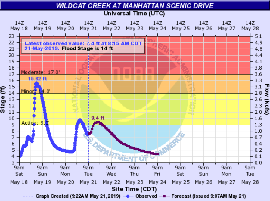
As for the foreseeable future, Wildcat Creek is not expected to rise into flood stage. At one time it was forecast to crest Tuesday at around 22 feet. The creek was hovering around 8 feet as late Tuesday morning and early afternoon, and not forecast to go much above that through the rest of the next three days.
As for Tuttle Creek Lake, it continues to rise as well, now up 1,125.90 feet as of this morning (50.90 feet above normal pool.) Riley County Emergency Management Director Pat Collins says as it approaches the second highest level in the lake’s history there is still about 30 percent capacity. There have been no talks of opening the emergency spillway.
Original story
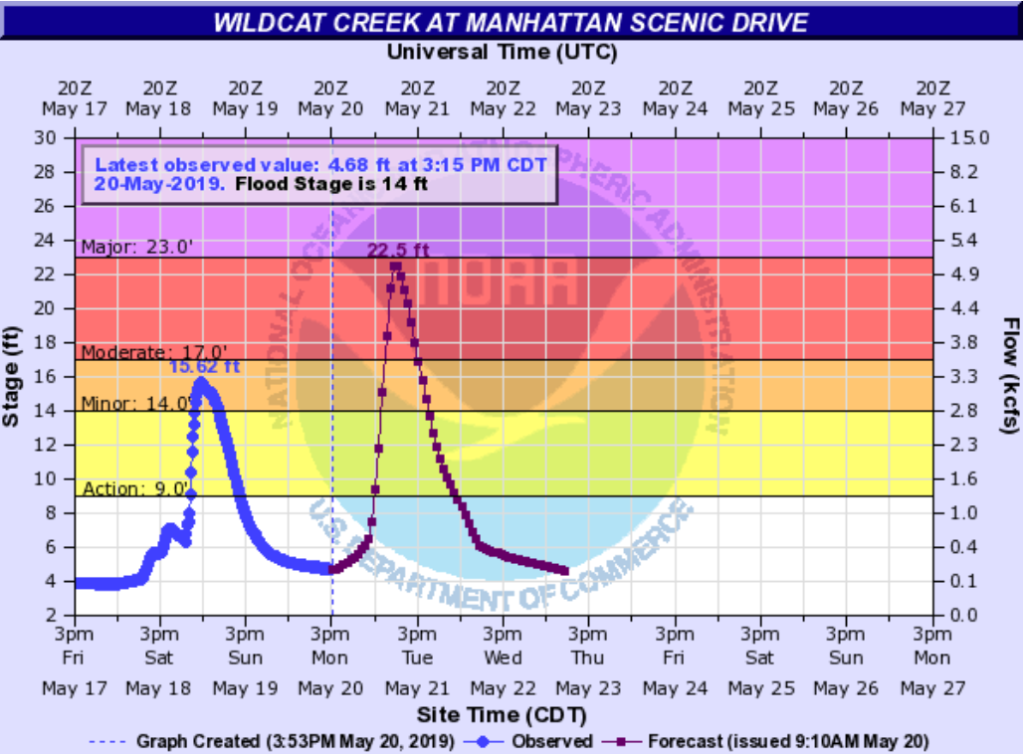
The National Weather Service is predicting Wildcat Creek will experience moderate flooding, cresting Tuesday morning.
As of 4 p.m. Monday, May 20, rainfall quantities between 1.5 to 4 inches are possible through Tuesday evening. A flash flood watch is in effect in Riley, Pottawatomie and Geary Counties through 7 p.m. Tuesday and a flood warning has been declared for Wildcat Creek as well as Fancy Creek near Randolph, Lyon Creek near Junction City and the Kansas River at Manhattan.
Manhattan Floodplain Manager Chad Bunger says current projections have Wildcat Creek topping out at 22.5 feet. Last week’s minimal flooding crested around 15 feet, 25 feet results in water flowing over Linear Trail and the Labor Day flood of Wildcat Creek reached a height of 28 feet.
The NWS indicates the major flood stage on Wildcat Creek begins at 23 feet. Bunger says projections this far out by the NWS is “unprecedented.
“I don’t know if I’ve ever seen them do this for Wildcat Creek where we get almost a day of advanced warning like this,” says Bunger. “Usually it occurs after we get a rain event in the watershed and some rainfall data is accumulated by the weather service and then they make a prediction.”
The early warning, Bunger says, demonstrates the importance of residents who live in the creek’s floodplain or who have been flooded during past events staying alert.
“I don’t know where the rainfall will land, it could land in a spot in the watershed where it causes minimal damage or is not as intense and we’re fortunate,” Bunger says. “Or it could rain in one spot all at one time and rain more than the amount to cause 22.5 feet of crest on Wildcat Creek and we’d have some serious problems.”
Bunger says while they cannot predict how things will play out, he calls the situation serious and urges residents to be prepared and follow the levels online if possible.
“Round up your important documents, those irreplaceable items that you can take with you and be ready to go at a moment’s notice if you live in the Wildcat Creek watershed.”
Items he specifically mentioned protecting included drivers licenses, passports, photo albums, important bills and electronics. Bunger says if you can’t take things with you, put the items that would suffer the most damage in a flood on a higher surface in your home. Residents in low-lying areas and floodplains are also advised to consider moving your vehicle to higher ground in order to not be stranded should your roadway flood.
Residents are also advised to subscribe to area emergency alerts online, monitor the Manhattan Flood Updates Facebook page, make sure your weather radios are powered up and never drive into flooded areas.