Close Menu

    Closings

    Facebook X (Twitter) Instagram
    • Personalities/Staff
    • Jobs
    • Calendar
    • Contest Rules
    • Contact Us
    • Privacy Policy
    • Login
    RSS Facebook X (Twitter)
    News Radio KMAN
    • Local/State News
      • Manhattan
      • Wamego
      • Riley County
      • Pottawatomie County
      • Fort Riley
      • Geary County
      • State News
      • RCPD Reports
    • Weather
    • Sports
      • K-State Sports
      • High School Sports
        • HS Basketball Schedule & Scores
          • Manhattan High
          • Wamego
          • Rock Creek
          • Riley County
          • Frankfort
          • Blue Valley High
      • Scoreboard Saturday
      • Student-Athlete of the Week
    • Podcasts
      • Within Reason with Mike Matson
      • The Game
      • Wildcat Insider
      • Scoreboard Saturday
    • Obituaries
    • Message Us
      • Birthday/Anniversary
    • Keep It Local
    Listen
    Closings And Delaystyle=
    News Radio KMAN
    You are at:Home»Local News»Severe weather expected Tuesday with hail, tornadoes, and flooding risks

    Severe weather expected Tuesday with hail, tornadoes, and flooding risks

    0
    By KMAN Staff on June 17, 2025 Local News

    Forecasters are urging residents to prepare for a potentially dangerous day of severe weather across the region on Tuesday, with threats that include large hail, damaging winds, tornadoes and flash flooding.

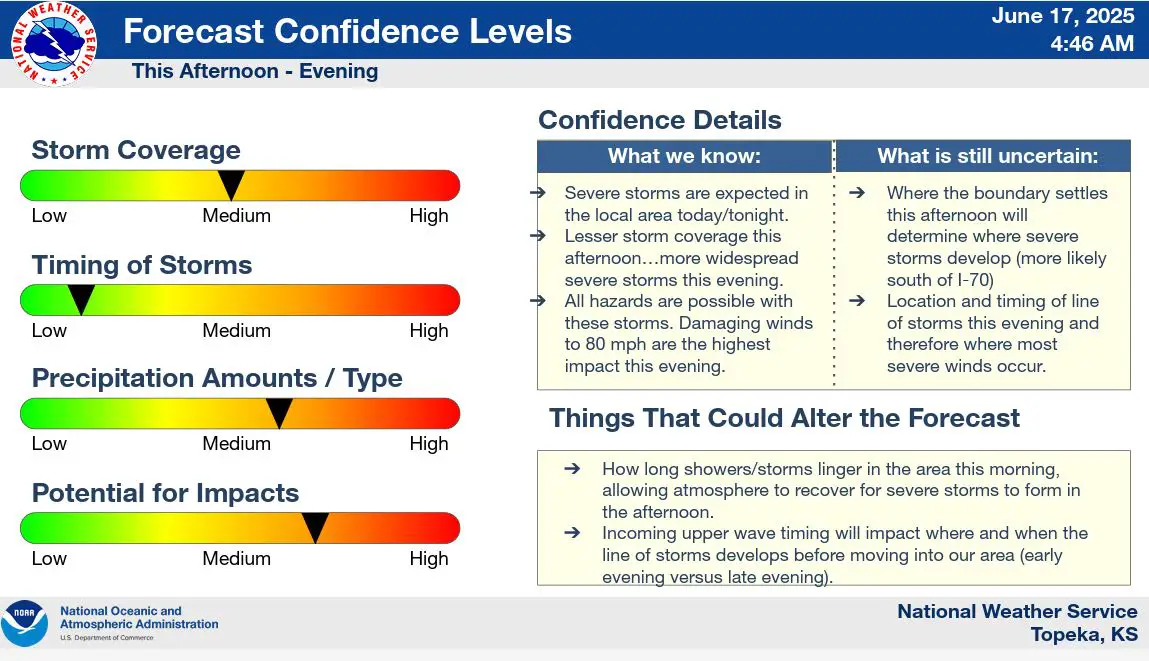
    Scattered light showers and non-severe storms will linger into early afternoon, with gusty winds up to 50 mph possible. A boundary setting up south of I-70 is expected to become the focus for storm development later this afternoon. If storms form along this boundary, they could bring very large hail, damaging wind gusts and isolated tornadoes.

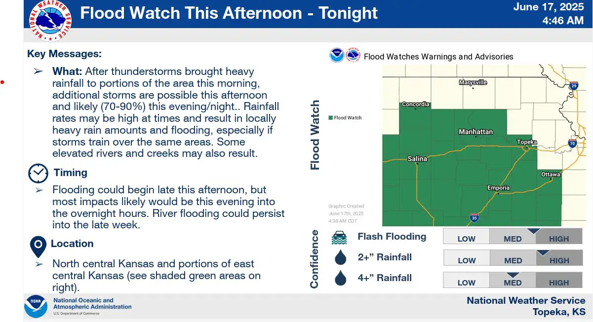
    A more widespread severe threat arrives this evening as a line of storms pushes in from the west. Damaging wind gusts remain the primary hazard, though large hail, a few tornadoes and flash flooding are also possible. A Flood Watch is in effect for portions of north central and northeast Kansas.

    The system is expected to exit the region by Wednesday morning.

    Stay tuned to News Radio KMAN for the latest updates.

    Click here for more local news.

    damaging winds Kansas flash flooding Kansas Flood Watch Kansas hail storm Kansas I-70 storm threat June 2025 storm forecast Kansas emergency weather alert Kansas severe weather Kansas tornado risk KMAN weather update
    Share. Facebook Twitter Pinterest LinkedIn Tumblr Email
    KMAN Staff
    • Website
    • Facebook
    • X (Twitter)

    Related Posts

    Fort Riley soldiers among troops that marched in Army parade

    Walmart reopens after fire in store

    RCPD believes recent business thefts connected

    Listen Live Here
    Listen Live - Mobile

    Categories

    EEO Report

    FCC Public File

    FCC Applications


    Follow @1350kman on Twitter · Manhattan Broadcasting Company is an equal opportunity employer.
    Manhattan Broadcasting does not discriminate in sale of advertising on the basis of race, gender, or ethnicity, and will not accept advertising which does so discriminate. © 2024 Manhattan Broadcasting Company.

    Type above and press Enter to search. Press Esc to cancel.