10 a.m. Saturday update
It now appears the first snow storm of the season will impact the area Saturday. Overnight, the National Weather Service in Topeka upgraded the Manhattan area to be included in the Winter Storm Warning in place through early Sunday that now spans a wide swath of the Flint Hills down to the Wichita area.
The Manhattan area is now forecast to see between 4 and 7 inches of snow accumulation. The heaviest snow is expected in the afternoon, and will likely persist through the evening hours.
The snow is likely to create hazardous driving conditions with falling snow reducing visibilities and creating slick, snow packed roads. If travel is necessary, go slow and give yourself extra time reaching the destination.
Closings and cancellations will be noted on our website throughout the day here.
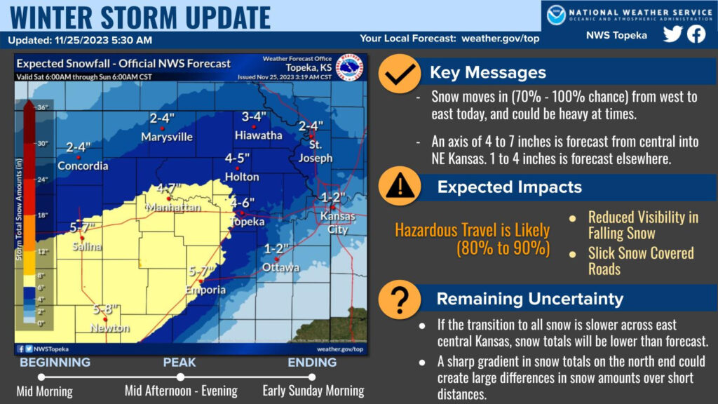
6:30 p.m. Friday
The National Weather Service has updated the forecast for Saturday’s anticipated snow storm, to include a Winter Weather Advisory for the Manhattan area. It is in place from 9 a.m. Saturday to 3 a.m. Sunday for Riley and Pottawatomie counties. Geary County is on the northern boundary of a Winter Storm Warning in place over that same timeframe.
Snow is expected to move into the area Saturday with a high likelihood of hazardous travel. In some areas, as much as 4 to 7 inches of snow accumulations are possible, with about 1 to 5 inches expected in the Manhattan area.
Some uncertainty remains: rain mixing in with snow across east central Kansas could cut back on snow totals in this area while a sharp gradient on the north end could create large differences in snow amounts over short distances.
Regardless, travel will be treacherous, so motorists are advised to delay travel if possible on Saturday. That may be difficult for those coming into Manhattan for the Kansas State vs. Iowa State football game, scheduled for 7 p.m. Snow is expected to begin early in the morning, with the peak snowfall anticipated by the afternoon. Snow will end by early Sunday morning.
Road conditions for those who must drive, can be found at kandrive.org.
7:30 a.m. Friday
Snow is forecast to fall in Manhattan Saturday, though how much and when, is still a bit uncertain.
The National Weather Service has issued a Winter Storm Watch, in place from Saturday morning through the evening for the area, with snow accumulations of 3 to 5 inches possible. Forecasters say confidence is high (between 70 to 90%) that there will be accumulating snow.
As for timing, the National Weather Service says the Manhattan area can expect precipitation to start sometime between 9 a.m. and noon, then tapering off sometime after midnight Sunday.
If you have plans to travel Saturday, it’s suggested you stay weather aware and alter them to avoid driving in winter weather.
Keep it tuned to KMAN and stay up to date with NewsRadioKMAN.com and our social media feeds for the latest on the weather conditions.