Close Menu

    Closings

    Facebook X (Twitter) Instagram
    • Personalities/Staff
    • Jobs
    • Calendar
    • Contest Rules
    • Contact Us
    • Privacy Policy
    • Login
    RSS Facebook X (Twitter)
    News Radio KMAN
    • Local/State News
      • Manhattan
      • Wamego
      • Riley County
      • Pottawatomie County
      • Fort Riley
      • Geary County
      • State News
      • RCPD Reports
    • Weather
    • Sports
      • K-State Sports
      • High School Sports
        • HS Basketball Schedule & Scores
          • Manhattan High
          • Wamego
          • Rock Creek
          • Riley County
          • Frankfort
          • Blue Valley High
      • Scoreboard Saturday
      • Student-Athlete of the Week
    • Podcasts
      • Within Reason with Mike Matson
      • The Game
      • Wildcat Insider
      • Scoreboard Saturday
    • Obituaries
    • Message Us
      • Birthday/Anniversary
    • Keep It Local
    Listen
    Closings And Delaystyle=
    News Radio KMAN
    You are at:Home»Local News»Storms bring hail, tornadoes to the region; more storms likely Friday

    Storms bring hail, tornadoes to the region; more storms likely Friday

    0
    By Brandon Peoples on August 16, 2019 Local News, Pottawatomie County, Riley County, Wabaunsee County

    Severe storms pushed through the region last night, knocking out power briefly to more than two thousand Manhattan residents.

    The storm dumped 2 to 4 inches of rain throughout most of the area, in addition to hail up to golf-ball size and prompted overnight flash flood warnings.

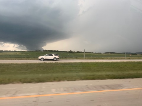
    Storms intensified further south. In Wabaunsee County, a few tornado warnings were issued last night, with some brief touchdowns noted by storm spotters near Volland and Eskridge. An official with the Wabaunsee County Sheriff’s Office tells KMAN the storms didn’t cause any widespread damage as most of the impact was over rural areas of the county.

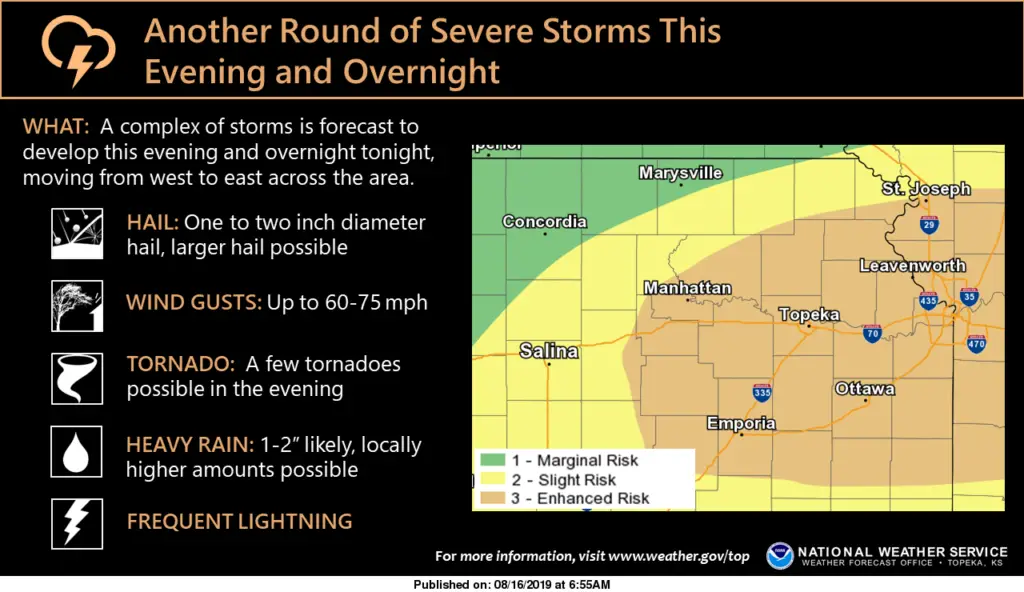
    The setup for Friday’s weather pattern is looking very similar. Large hail, damaging wind gusts and locally heavy rainfall are all possible and tornadoes can not be ruled out. The National Weather Service says exact storm locations will become more clear throughout the morning and into the early afternoon today as the warm front can be more easily identified.

    Photo taken near Manhattan Regional Airport. Photo courtesy Angela Morgan Trapp

    Share. Facebook Twitter Pinterest LinkedIn Tumblr Email
    Brandon Peoples
    • Website

    KMAN News Director and host of In Focus. Contact Brandon at Brandon@1350KMAN.com

    Related Posts

    Bobian appeals conviction for 2023 murder of wife

    Police board continues to debate 2026 budget

    Manhattan woman and two others hurt in crash near Milford State Park

    Listen Live Here
    Listen Live - Mobile

    Categories

    EEO Report

    FCC Public File

    FCC Applications


    Follow @1350kman on Twitter · Manhattan Broadcasting Company is an equal opportunity employer.
    Manhattan Broadcasting does not discriminate in sale of advertising on the basis of race, gender, or ethnicity, and will not accept advertising which does so discriminate. © 2024 Manhattan Broadcasting Company.

    Type above and press Enter to search. Press Esc to cancel.

    x