Close Menu

    Closings

    Facebook X (Twitter) Instagram
    • Personalities/Staff
    • Jobs
    • Calendar
    • Contest Rules
    • Contact Us
    • Privacy Policy
    • Login
    RSS Facebook X (Twitter)
    News Radio KMAN
    • Local/State News
      • Manhattan
      • Wamego
      • Riley County
      • Pottawatomie County
      • Fort Riley
      • Geary County
      • State News
      • RCPD Reports
    • Weather
    • Sports
      • K-State Sports
      • High School Sports
        • HS Basketball Schedule & Scores
          • Manhattan High
          • Wamego
          • Rock Creek
          • Riley County
          • Frankfort
          • Blue Valley High
      • Scoreboard Saturday
      • Student-Athlete of the Week
    • Podcasts
      • Within Reason with Mike Matson
      • The Game
      • Wildcat Insider
      • Scoreboard Saturday
    • Obituaries
    • Message Us
      • Birthday/Anniversary
    • Keep It Local
    Listen
    Closings And Delaystyle=
    News Radio KMAN
    You are at:Home»Local News»Dangerous winds, fire danger, record temps to bear down on Flint Hills Wednesday

    Dangerous winds, fire danger, record temps to bear down on Flint Hills Wednesday

    0
    By Brandon Peoples on December 14, 2021 Local News, Manhattan, Pottawatomie County, Riley County
    National Weather Service Topeka courtesy graphic
    National Weather Service Topeka courtesy graphic
    National Weather Service Topeka courtesy graphic
    National Weather Service Topeka courtesy graphic

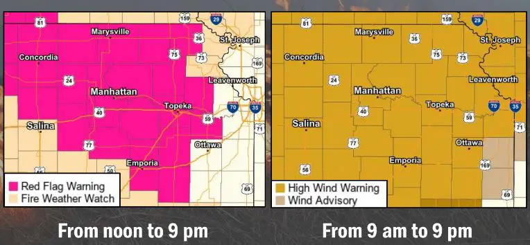
    Extreme fire danger is in place for the Flint Hills for the next 24 hours as a deep low pressure system develops Wednesday which will generate high winds area wide.

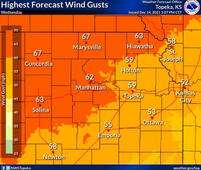
    The National Weather Service in Topeka has issued a high wind warning in effect 9 a.m. to 9 p.m. Wednesday with red flag warnings in effect noon to 9 p.m. for very strong southerly winds of 30 to 40 mph. Wind gusts up to 70 mph are expected and that could snap tree limbs, blow over power lines and make difficult driving conditions, especially along Interstate 70.

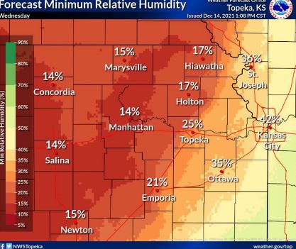
    Couple that with very low relative humidity, as low as 14 percent in some spots, and it’s a perfect recipe to spark a wildfire. Those levels are expected to drop after 2 p.m. A few storms are possible late Wednesday evening as well.

    Record warmth is expected Wednesday, with Manhattan’s forecast high near 75 degrees. That would smash the current record for Dec. 15 of 69 degrees set back in 2002. The warmest temperature ever recorded in Manhattan this late in the season is 73 degrees, recorded Dec. 17, 1939.

    Share. Facebook Twitter Pinterest LinkedIn Tumblr Email
    Brandon Peoples
    • Website

    KMAN News Director and host of In Focus. Contact Brandon at Brandon@1350KMAN.com

    Related Posts

    Truck driver arrested after fatal pedestrian accident

    RCPD officials say there have been less cars broken into this spring but more stolen cars

    Junction City man faces multiple charges for vehicle burglaries

    Listen Live Here
    Listen Live - Mobile

    Categories

    EEO Report

    FCC Public File

    FCC Applications


    Follow @1350kman on Twitter · Manhattan Broadcasting Company is an equal opportunity employer.
    Manhattan Broadcasting does not discriminate in sale of advertising on the basis of race, gender, or ethnicity, and will not accept advertising which does so discriminate. © 2024 Manhattan Broadcasting Company.

    Type above and press Enter to search. Press Esc to cancel.

    x