Close Menu
  • News
    • Manhattan
    • Riley County
    • Pottawatomie County
    • Geary County
    • Fort Riley
    • RCPD Reports
    • Wamego
    • State News
  • Sports
    • High School Sports
      • HS Football Schedule & Scores
        • Centennial League
        • NCKL
        • Big East League
        • Flint Hills League
        • Twin Valley League
    • K-State Sports
    • Scoreboard Saturday
    • Student-Athlete of the Week
  • Weather
  • Obituaries
  • Birthdays/Anniversaries
  • Keep It Local
    • KMAN Broadcast Calendar
    • The Manhattan Mercury
    • Personalities/Staff
    • Contact Us
  • Podcasts
    • Within Reason with Mike Matson
    • The Game
    • Wildcat Insider
    • Scoreboard Saturday
    • WeatherWise with Chip Redmond

Closings

Facebook X (Twitter) Instagram
  • Jobs
  • Calendar
  • Contest Rules
  • Privacy Policy
  • Login
TOP STORIES
  • Downtown’s Sinkers Lounge announces closure
  • City commission to vote on Edge District financing
  • Woman loses more than $1,100 in Facebook job scam
  • RCPD Report: 6/12/26
  • Police board holds special meeting for private executive session
  • Wamego, Rock Creek land All-State softball selections
  • AFTERMATH | Couple says tree that fell through roof also caused significant water damage
  • Pawnee funding increase takes hit in initial Riley County budget discussion
News Radio KMAN
  • News
    • Manhattan
    • Riley County
    • Pottawatomie County
    • Geary County
    • Fort Riley
    • RCPD Reports
    • Wamego
    • State News
  • Sports
    • High School Sports
      • HS Football Schedule & Scores
        • Centennial League
        • NCKL
        • Big East League
        • Flint Hills League
        • Twin Valley League
    • K-State Sports
    • Scoreboard Saturday
    • Student-Athlete of the Week
  • Weather
  • Obituaries
  • Birthdays/Anniversaries
  • Keep It Local
    • KMAN Broadcast Calendar
    • The Manhattan Mercury
    • Personalities/Staff
    • Contact Us
  • Podcasts
    • Within Reason with Mike Matson
    • The Game
    • Wildcat Insider
    • Scoreboard Saturday
    • WeatherWise with Chip Redmond
Facebook X (Twitter) Instagram YouTube
News Radio KMAN
Facebook X (Twitter) Instagram
Listen
You are at:Home»Top Story»Large hail, tornadoes possible as severe storms target NE Kansas

Large hail, tornadoes possible as severe storms target NE Kansas

0
By KMAN Staff on May 17, 2026 Top Story

Northeast Kansas faces an increasing threat for severe weather Sunday and Monday, including the potential for large hail, damaging winds, tornadoes and flash flooding, according to the National Weather Service in Topeka.

Forecasters have placed much of central and northeast Kansas under an enhanced risk, or level 3 out of 5, for severe storms Sunday. Storms are expected to develop in western Kansas between 5 and 7 p.m. before moving east through the overnight hours. Hazards could include golf ball- to baseball-sized hail, wind gusts exceeding 70 mph, isolated tornadoes and localized flash flooding.

The National Weather Service said confidence is increasing in the types of hazards expected, although some uncertainty remains regarding exactly where storms will develop because of the position of a dryline and atmospheric capping.

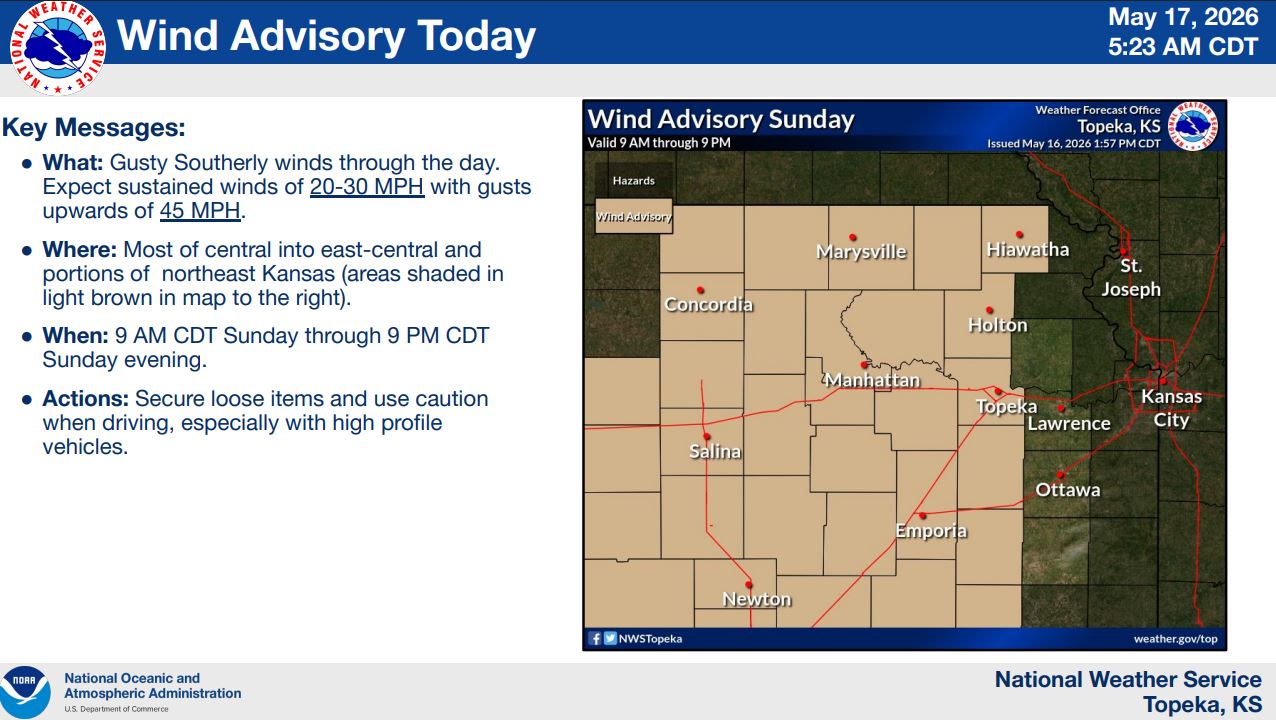
A wind advisory is also in effect from 9 a.m. to 9 p.m. Sunday for much of central, east-central and northeast Kansas. Sustained south winds of 20 to 30 mph with gusts up to 45 mph are expected. Residents are urged to secure loose outdoor items and use caution while driving, especially in high-profile vehicles.

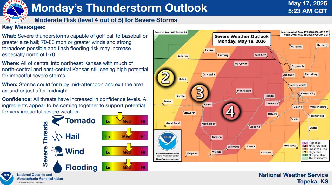
The severe weather threat is expected to intensify Monday, when the Storm Prediction Center has placed portions of Kansas under a moderate risk, or level 4 out of 5, for severe storms. The National Weather Service warned that all ingredients appear to be coming together for “very impactful severe weather.”

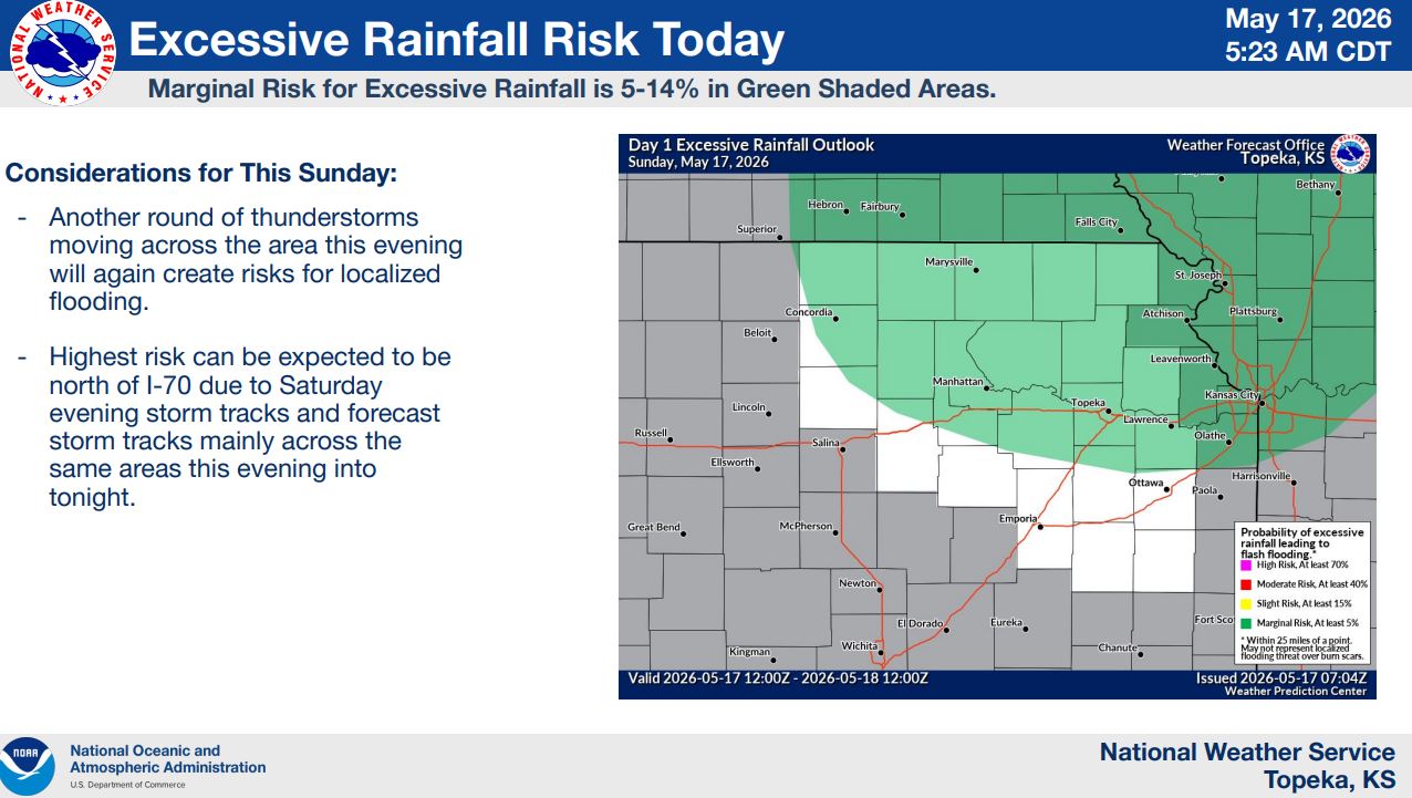
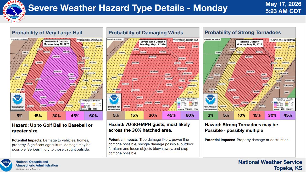
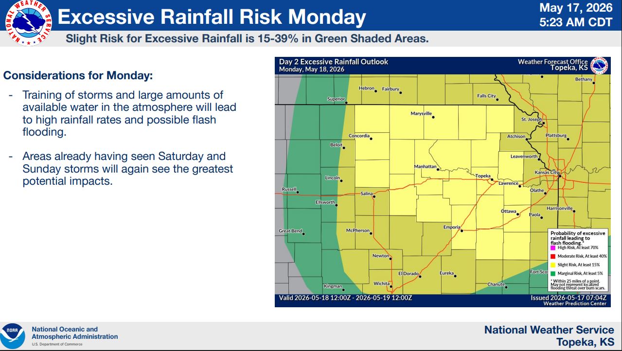
Monday’s storms could produce hail larger than baseballs, wind gusts between 70 and 80 mph and strong tornadoes, possibly multiple. Flash flooding will also become more likely as repeated rounds of storms move across areas already saturated by weekend rainfall.

Forecasters say storms could begin developing by midafternoon Monday and continue into the overnight hours. Areas north of Interstate 70 may see the greatest flooding concerns due to repeated storm activity.

Stay tuned to News Radio KMAN for the latest updates.

Share. Facebook Twitter Pinterest LinkedIn Tumblr Email
KMAN Staff
  • Website
  • Facebook
  • X (Twitter)

Related Posts

Manhattan baseball returns to state with regional championship

McCool’s in Aggieville to close at the end of May

Ex-RCPD officer to stand trial in September

LISTEN LIVE HERE
LISTEN LIVE - MOBILE

EEO Report

FCC Public File

FCC Applications


Manhattan Broadcasting Company is an equal opportunity employer.
Manhattan Broadcasting does not discriminate in sale of advertising on the basis of race, gender, or ethnicity, and will not accept advertising which does so discriminate. © 2026 Manhattan Broadcasting Company.


Follow @1350kman on Twitter · Manhattan Broadcasting Company is an equal opportunity employer.
Manhattan Broadcasting does not discriminate in sale of advertising on the basis of race, gender, or ethnicity, and will not accept advertising which does so discriminate. © 2026 Manhattan Broadcasting Company.
  • News
    • Manhattan
    • Riley County
    • Pottawatomie County
    • Geary County
    • Fort Riley
    • RCPD Reports
    • Wamego
    • State News
  • Sports
    • High School Sports
      • HS Football Schedule & Scores
        • Centennial League
        • NCKL
        • Big East League
        • Flint Hills League
        • Twin Valley League
    • K-State Sports
    • Scoreboard Saturday
    • Student-Athlete of the Week
  • Weather
  • Obituaries
  • Birthdays/Anniversaries
  • Keep It Local
    • KMAN Broadcast Calendar
    • The Manhattan Mercury
    • Personalities/Staff
    • Contact Us
  • Podcasts
    • Within Reason with Mike Matson
    • The Game
    • Wildcat Insider
    • Scoreboard Saturday
    • WeatherWise with Chip Redmond

Type above and press Enter to search. Press Esc to cancel.